ARTIKULUAK
-
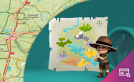
GeoExplorer

GeoExplorer has come to discover the Earth through games to learn astronomy, the interior of the Earth, geography and maps. Draw, colour, cut and learn more with links to other resources. Aimed at students aged from 6 to 12 years. https://www.ign.es/web/resources/acercaDe/libDigPub/Geoexplorer_en.pdf
- mapa
- libro
- astronomía
- tierra
- terremoto
- volcán
- volcanes
- dibujo
- dibujar
- colorear
- recortar
- actividad
- cartografía
- Geografía
- juego
- jugar
- mapa
- país
- província
- región
- gamificación
- continente
- mundo
- mundial
- río
- montaña
- cordillera
- Física
- política
- bandera
- placas tectónicas
- Litosfera
- pico
- cabo
- Golfo
- isla
- archipiélago
- capital
- ciudad
- infantil
- Primaria
Jakintza-arloHezkuntza-testuingurua -
GeoExplorer
GeoExplorer ha venido a descubrir la Tierra a través de juegos para aprender astronomía, el interior de la Tierra, geografía y mapas. Dibuja, colorea, recorta y aprende más con enlaces a otros recursos. Dirigido a estudiantes de entre 6 y 12 años. https://www.ign.es/web/resources/acercaDe/libDigPub/Geoexplorer_es.pdf
- mapa
- libro
- astronomía
- tierra
- terremoto
- volcán
- volcanes
- dibujo
- dibujar
- colorear
- recortar
- actividad
- cartografía
- Geografía
- juego
- jugar
- mapa
- país
- província
- región
- gamificación
- continente
- mundo
- mundial
- río
- montaña
- cordillera
- Física
- política
- bandera
- placa
- tectónica
- Litosfera
- pico
- cabo
- Golfo
- isla
- archipiélago
- capital
- ciudad
- infantil
- Primaria
Jakintza-arloHezkuntza-testuingurua -
GeoSapiens App

GeoSapiens tests your knowledge of physical, political and landscape geography. Review the names of the main features of land and coastal relief, countries, capitals, regions, flags and much more. It contains games from Spain, by autonomous region, the world and by continent. Play, score points and share your results. Suitable for all ages. English and Spanish. https://www.ign.es/web/ign/portal/dir-aplicaciones-moviles
- ign
- aplicación
- app
- juego
- jugar
- gamificación
- Geografía
- cartografía
- mapa
- comunidad
- autónoma
- país
- província
- región
- regiones
- capital
- Capitales
- municipio
- territorio
- continente
- mundo
- mundial
- río
- relieve
- montaña
- cordillera
- Lago
- Embalse
- Física
- política
- bandera
- Cuenca
- hidrografía
- placas tectónicas
- fosa
- dorsal
- costa
- costero
- pico
- cabo
- Golfo
- isla
- archipiélago
- ciudad
- Zonas
- parque nacional
- natural
- protegido
- regional
- rural
- paisaje
Jakintza-arloHezkuntza-testuingurua -
GeoSapiens App
Aplicación móvil de mapas interactivos para estudiar la geografía física, política y el paisaje de España y el mundo. Es bilingüe en español e inglés y la mayoría de los juegos no requieren conexión a internet. Repasa los nombres de los principales accidentes del relieve terrestre y costero, los países, capitales, regiones, banderas y mucho más. Contiene juegos de España, por comunidad autónoma, del mundo y por continente. Juega y suma puntos. Dirigido a todas las edades. En español e inglés....
- ign
- aplicación
- app
- juego
- jugar
- gamificación
- Geografía
- cartografía
- mapa
- comunidad
- autónoma
- país
- província
- región
- regiones
- capital
- Capitales
- municipio
- territorio
- continente
- mundo
- mundial
- río
- relieve
- montaña
- cordillera
- Lago
- Embalse
- Física
- política
- bandera
- Cuenca
- hidrografía
- placa
- tectónica
- fosa
- dorsal
- costa
- costero
- pico
- cabo
- Golfo
- isla
- archipiélago
- ciudad
- Zonas
- proteger
- parque
- nacional
- natural
- regional
- rural
- paisaje
Jakintza-arloHezkuntza-testuingurua -
GeoSapiens

GeoSapiens tests your knowledge of physical, political and landscape geography. Review the names of the main features of land and coastal relief, countries, capitals, regions, flags and much more. It contains games from Spain, by autonomous region, the world and by continent. Create your customized game and share it with your class. Play, score points and share your results. Suitable for all ages. https://educativo.ign.es/geosapiens/htm/es/index.html
- aplicación
- cartografía
- comunidad autónoma
- Geografía
- juego
- jugar
- mapa
- país
- província
- región
- regiones
- territorio
- gamificación
- continente
- mundo
- mundial
- río
- montaña
- cordillera
- Lago
- Embalse
- Física
- política
- bandera
- Cuenca
- hidrografía
- placa
- tectónica
- fosa
- dorsal
- costa
- costero
- pico
- cabo
- Golfo
- isla
- archipiélago
- capital
- ciudad
Jakintza-arloHezkuntza-testuingurua -
GeoSapiens
GeoSapiens pone a prueba tus conocimientos sobre geografía física, política y paisaje. Repasa los nombres de los principales accidentes del relieve terrestre y costero, los países, capitales, regiones, banderas y mucho más. Contiene juegos de España, por comunidad autónoma, del mundo y por continente. Dirigido a todas las edades. También se ofrece este recurso en inglés. https://educativo.ign.es/geosapiens/htm/es/index.html
- aplicación
- cartografía
- comunidad autónoma
- Geografía
- juego
- jugar
- mapa
- país
- província
- región
- regiones
- territorio
- gamificación
- continente
- mundo
- mundial
- río
- cordillera
- Lago
- Embalse
- Física
- política
- bandera
- Cuenca
- hidrografía
- placa
- tectónica
- fosa
- dorsal
- costa
- costero
- pico
- cabo
- Golfo
- isla
- archipiélago
- capital
- ciudad
Jakintza-arloHezkuntza-testuingurua -
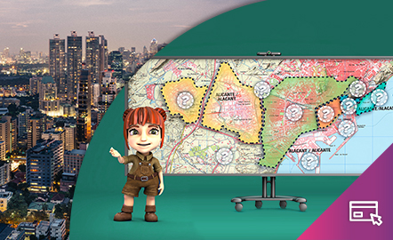
The city

The aim of this interactive teaching and learning resource is to differentiate between urban spaces and their different features by reading a map. The medium used is a game in which the different areas of the city are shown and, according to the characteristics indicated, the user must point to them on the map. Aimed at students aged from 12 to 16 years. Year of creation: 2020. https://www.ign.es/recursos-educativos/descubre-territorio/ciudad.html
Jakintza-arloHezkuntza-testuingurua -
La ciudad
Este recurso interactivo y didáctico tiene como objetivo diferenciar los espacios urbanos y sus diferentes funciones mediante la lectura cartográfica. El soporte es un juego en el que se van explicando las diferentes zonas de la ciudad y el usuario, según las características indicadas, debe ir señalándolas en el mapa. Dirigido a estudiantes de edades de entre 12 y 16 años. Actualizado en 2020. También se ofrece este recurso en inglés. https://www.ign.es/recursos-educativos/descubre-...
Jakintza-arloHezkuntza-testuingurua -
Geographical names
This interactive teaching and learning resource looks at the importance of geographical names in the representation of territory. On maps, toponyms, in addition to identifying and locating places, give us information according to the size, colour and type of letters used. The method used makes it possible to set small challenges that are easily answered, with the aim of favouring the learning process. Aimed at students aged from 10 to 12 years. https://www.ign.es/recursos-educativos/de...
Jakintza-arloHezkuntza-testuingurua -
Topónimos

Este recurso interactivo y didáctico incide en la importancia de los nombres geográficos en la representación del territorio. En los mapas, los topónimos, además de identificar y localizar los lugares, nos dan información según el tamaño y el color y el tipo de letra utilizados. El método utilizado permite plantear pequeños retos fáciles de responder con el objetivo de favorecer el aprendizaje. Dirigido a estudiantes de 10 a 12 años. Actualizado en 2020. También se ofrece este recurso ...
Jakintza-arloHezkuntza-testuingurua